| |
| Date (local) | January 12, 2010, 16:53 |
|---|---|
| Magnitude | 7.0 Mw |
| Depth: | 13 km |
| Epicenter location | near Port-au-Prince |
| Tsunami: | yes |
| Casualties: | ca. 300,000 |
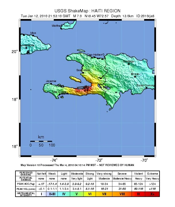
On Tuesday, January 12, 2010, at 04:53 PM local time (21:53 UTC), an earthquake with a magnitude of 7.3 occurred 25 km westsouthwest of Port-au-Prince, Haiti, near the town of Grand Goave. The main shock was felt as far away as Florida and Venezuela. The earthquake caused major damage to most houses in the region of Port-au-Prince. Around 300,000 people were found dead[1], around the same number were injured. This makes the Haiti earthquake the second-deadliest seismic event that was ever recorded. Only the Shaanxi earthquake in 1556 caused more losses of life. The tsunami that was triggered by the earthquake reached up to 3 meters on the southern shore of Hispanola island.[2]
The place where the earthquake hit is on the Enriquillo-Plantain Garden fault system, a transformation fault where the Caribbean plate slips along the North American plate.
Significant shocks[]
Only shocks with a magnitude equal to or higher than 5.0 are listed. Magnitudes from 6.0 are marked in bold. The main shock is colored in green.
| Date | Time (UTC) | Magnitude | Epicenter | Depth (km) | Additional information |
|---|---|---|---|---|---|
| 12 Jan | 21:53:10 | 7.0 | 18.449°N, 72.543°W | 13 | |
| 12 Jan | 22:00:41 | 6.0 | 18.386°N, 72.785°W | 10 | |
| 12 Jan | 22:07:02 | 5.0 | 18.46°N, 72.63°W | 10 | |
| 12 Jan | 22:12:04 | 5.7 | 18.452°N, 72.513°W | 10 | |
| 12 Jan | 23:12:03 | 5.3 | 18.40°N, 72.52°W | 10 | |
| 13 Jan | 00:43:27 | 5.0 | 18.48°N, 72.48°W | 10 | |
| 13 Jan | 00:59:05 | 5.2 | 18.35°N, 72.85°W | 10 | |
| 13 Jan | 01:16:51 | 5.1 | 18.42°N, 72.85°W | 10 | |
| 13 Jan | 01:32:44 | 5.3 | 18.38°N, 72.94°W | 10 | |
| 13 Jan | 01:36:31 | 5.4 | 18.41°N, 72.83°W | 10 | |
| 13 Jan | 01:57:34 | 5.4 | 18.41°N, 72.90°W | 10 | |
| 13 Jan | 02:11:30 | 5.0 | 18.42°N, 73.00°W | 10 | |
| 13 Jan | 05:02:57 | 5.8 | 18.369°N, 72.932°W | 10 | |
| 13 Jan | 05:18:02 | 5.2 | 18.34°N, 72.92°W | 10 | |
| 13 Jan | 07:23:04 | 5.0 | 18.35°N, 72.88°W | 10 | |
| 13 Jan | 14:43:44 | 5.3 | 18.45°N, 72.92°W | 10 | |
| 20 Jan | 11:03:43 | 5.9 | 18.422°N, 72.813°W | 10 |